

Kitsap Umbrella MB
SINCLAIR INLET
SITES OVERVIEW
Waterman Mitigation Partners is proposing an umbrella mitigation bank on the Kitsap Peninsula between Hood Canal and Puget Sound. The first proposed site to be considered for mitigation actions is ROSS CREEK, a part of the SINCLAIR INLET WATERSHED.
Additional Sinclair Inlet watershed intro information here…

Sinclair Inlet KUMB sites proposed
ROSS CREEK
The Ross Creek Bank Site (Ross Creek) is located west of the city of Port Orchard and empties into the south side of Sinclair Inlet.
The creek and uplands have been logged and residential development has begun encroaching, and plans are emerging for more development and construction.
After 150 years of activity and impacts Ross Creek is in need of a collaborative effort to restore, preserve, and protect this vital salmon and wetland habitat perched amid growing suburban activity.

WMP's timeline to restore the Ross Creek estuary aligns with WSDOT plans to replace the culvert with a bridge across Hwy 166.

Ross Creek estuary - currently blocked with fill with a small culvert restricting fish passage
The Ross Creek Subwatershed is comprised of three distinct areas:
1. nearshore with intertidal and estuary components that are artificially separated by SR 166,
2. lower segment of Ross Creek between SR 166 and SR 16, and
3. the upper segment of Ross Creek, south of SR 16 to its headwaters. The proposed bank site has multiple properties in the nearshore and lower segment of Ross Creek.
The proposed bank site encompasses five intertidal parcels and the entire estuary and lower segment of Ross Creek, affording opportunity to re-establish, rehabilitate, enhance, and protect critical intertidal and estuarine habitat and a stream system along a busy state route and area experiencing commercial and residential development pressure.
Ross Creek is considered a valuable bank site for the following reasons:
▪ Locates a mitigation bank in critical estuary habitat for salmon and other aquatic species;
▪ Provides both in-kind replacement of functions for freshwater impacts and out-of-kind replacement of functions for ESA-only habitat impacts;
▪ Preserves and protects high quality estuary, stream, palustrine wetlands, and the lower subwatershed under threat of on-going degradation in absence of mitigation bank activities; and
▪ Augments ecologically but does not earn credits for a planned WSDOT culvert replacements under SR 16 and SR 166 to improve estuary function and fish passage.

Aerial footage of Lower Ross Creek.
footage of ross creek rail car bridge, creek blockage
ADDITIONAL SINCLAIR INLET SITES
GORST SHORELINE + GORST CREEK HEADWATERS + OLD MILL POND
The Gorst Creek Site is comprised of three distinct areas:
1. nearshore sites near the mouth of Gorst Creek and north shoreline of Sinclair Inlet.
2. a middle segment represented by a city of Bremerton property.
3. an upper segment/headwaters represented by private forest land
Mitigation and restoration efforts for Gorst Creek and the Gorst shoreline include:
Remove creosote pilings along the shoreline.
Replace culvert to Old Mill Pond to promote natural tidal flow.
Restore and enhance areas north and south of the pond.
Remove hazardous debris along the shoreline and stabilize and revegetate beach.
Preserve and enhance Gorst Creek headwaters.

The pond that forms a barrier lagoon is hydrologically constricted from the original estuary by a submerged culvert under the PSNS railway. The current Mill Pond inflow / outflow create a difficult passage for fish.
OLD MILL POND (viking fence pond)


Restoring the properties and removing impacts from prior uses would protect highly valuable intertidal, freshwater and estuarine wetland, stream, and floodplain habitat from further degradation and development pressure.
Gorst Creek is considered a valuable bank site for the following reasons:
Locates a mitigation bank in critical estuary habitat for salmon and other aquatic species;
Addresses ecological concerns in watershed analyses conducted by local tribes and regulatory agencies;
Provides both in-kind replacement of functions for nearshore and freshwater impacts and out-of-kind replacement of functions for ESA-only habitat impacts;
Potential to alleviate flooding problems in the lower segment and at mouth and potential to improve surface water supply in the stream system; and
Preserves and protects estuarine and palustrine wetlands, stream, headwater wetlands, and a subwatershed under threat of on-going degradation in absence of mitigation bank activities.
Aerial footage showing the ‘Viking’ Pond (Old Mill pond) on the Gorst shoreline.
GORST CREEK HEADWATERS


Gorst Creek Wetland Headwaters
WRIGHT CREEK
Wright Creek drains into Sinclair Inlet between Gorst and the Puget Sound Naval Shipyard.
The creek estuary was partially filled during the mid-20th century and the estuary fill area is at risk to be developed again if restoration efforts do not move forward soon. Removing the fill dirt and existing structures, regrading and revegetating the estuary would substantially improve the functions of the estuary, including fish and wildlife habitat.

The Wright Creek Subwatershed extends upstream approximately 1.5 miles north and northwest from its mouth at Sinclair Inlet in an intertidal habitat with a small estuary bisected by all lanes of SR 3 and W. Sherman Heights Road. The nearshore area, in which the proposed bank site is located, lower segment, and south half of the upper segment are in Kitsap County jurisdiction and the remainder of the upper segment is within the West Bremerton UGA

The bank site is proposed on a privately owned residential parcel and a section of public right-of-way where there is opportunity to remove fill, remove garbage, and re-establish portions of the estuary shoreline and riparian corridor along a Type F stream that drains to Sinclair Inlet. Restoring this site and removing impacts from prior uses would protect highly valuable intertidal and estuarine habitat from further degradation and development pressure.
Wright Creek is considered a valuable bank site for the following reasons:
▪ Locates a mitigation bank in critical intertidal and estuary habitat for salmon and other aquatic species;
▪ Provides in-kind replacement of functions for nearshore impacts;
▪ Preserves and protects intertidal and estuary habitat under threat of on-going degradation from adjoining land uses in absence of mitigation bank activities; and
▪ Augments ecologically but does not earn credit for a planned WSDOT culvert replacement under SR 3 to improve estuary function and fish passage.
Aerial footage showing the flow of Wright Creek into Sinclair inlet.
PORT WASHINGTON NARROWS
The Port Washington Narrows Bank Site consists of three nearshore sites that lie along Port Washington Narrows’s shoreline: the coal dock at Lions Park, Pat Carey Vista, and the Kitsap County Consolidated Housing Authority properties. The properties comprising this bank site are tidally connected.
These properties provide opportunities for restoring nearshore functions along a heavily used marine corridor by removing overwater and in-water structures and enhancing intertidal habitat.


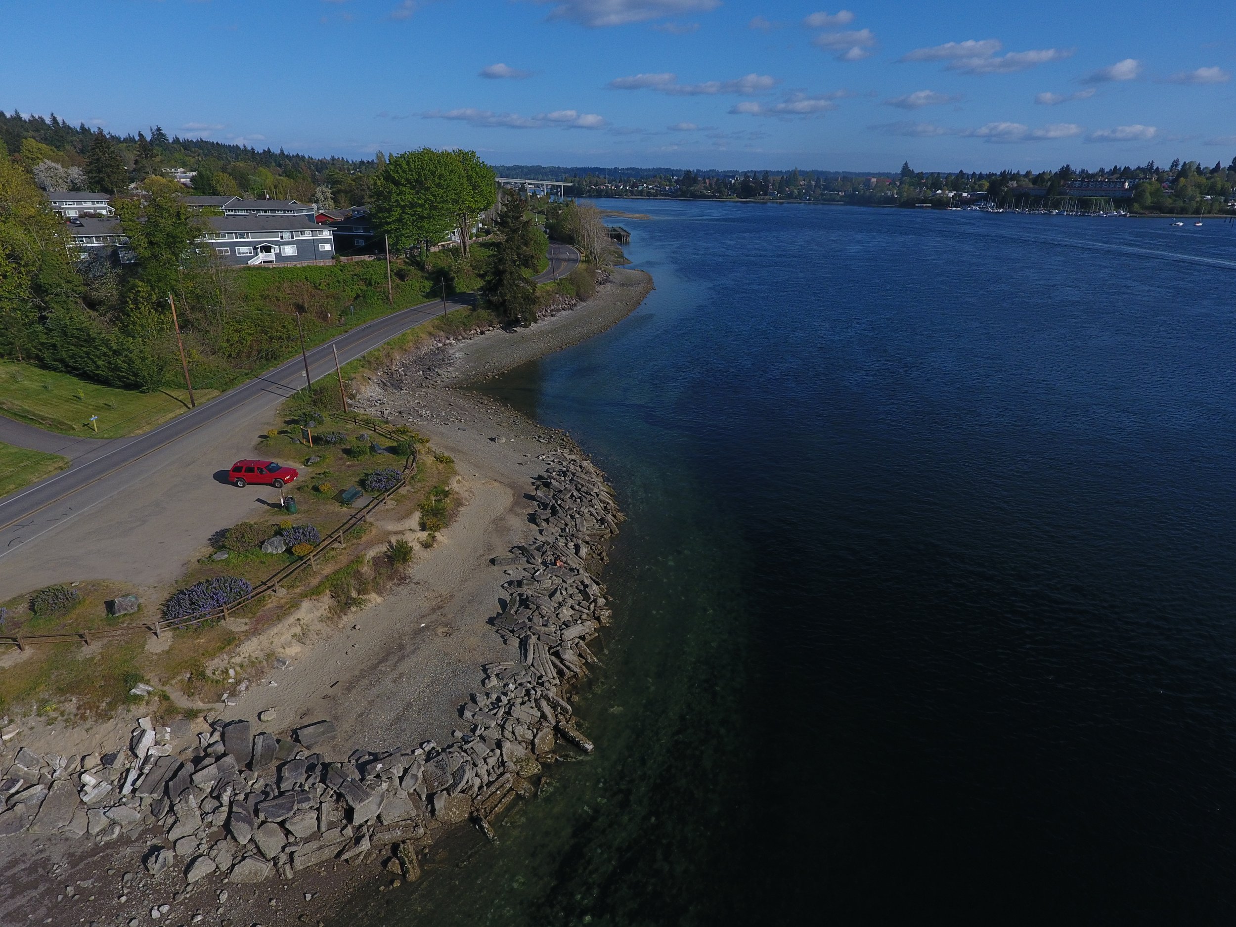
Pat Carey Vista shoreline
The Narrows Site is considered a valuable bank site for the following reasons:
▪ Locates bank site along a major marine corridor and enhances Dyes Inlet’s capacity to support federally listed and keystone species;
▪ Provides in-kind replacement of function for intertidal impacts;
▪ Preserves and protects high quality nearshore habitat and subwatershed under threat of on-going degradation in absence of mitigation bank activities; and
▪ Augments ecologically but does not earn credit for existing restoration work in Dyes and Sinclair Inlets to improve nearshore function, tidal flows, and fish passage.